To us, the best part of Tenerife is its great and diverse nature, which is best explored by foot. Here is our 1-3 week travel itinerary for people who like hiking and want to explore the best of Tenerife. We visited Tenerife for 12 days (incl. travel days), which was enough to get a good first impression. You can also shorten the itinerary to one week or extend it to three weeks.
Preparations
Where to Stay
Most hikes are in one of the three national parks: Anaga (north), Teide (center), and Teno (west). To explore all three, we split our trip into two and stayed half the time in the north and half in the south.

As a base in the north, we stayed at an apartment in Bajamar that we can very much recommend. The host is super friendly and helpful, there is a pool, a fully equipped kitchen, and a balcony with sunset views over the ocean. Bajamar is a small town on the north-west coast, roughly 1h driving from the Tenerife south airport. It has its own supermarket, pharmacy, beach, and natural pools. It is also well located for hiking in the north of Tenerife, including Agana national park.

In the south, we stayed at Finca Gaia La Segunda. At this finca you can rent either small villas or “glamping” tents that are located among fruit plantations overlooking the ocean. The area is really peaceful, there is a pool, and it is quite close to Los Gigantes, Teide national park, and Teno national park.

Getting Around
For this Tenerife hiking itinerary, you need a car. They are rather cheap to rent and the roads are in good condition. We rented from TopCar and can recommend it. Parking is often free.
For some hikes (laurel forest, El Teide, Masca), you will need an extra permit. They can be reserved online but are very limited and hard to get. More details and links in the corresponding hikes below. But don’t worry, most hikes do not require any permit or particular preparation.
Hikes in the North of Tenerife
The first part of our Tenerife hiking itinerary is in the north. The northern part of Tenerife is very green and has the Anaga national park in the north west, which is our favorite for hiking. It can be reached from Bajamar in around 30min by car.
Roque de Taborno
1h 15min, 4.2km, 300m total elevation gain, easy/intermediate difficulty


The “Roque de Taborono” is a peak that looks a bit like a small Matterhorn. This hike starts in the village of Taborno. Walk past the small, red church, following the path on the right. Keep following the path towards and around the mountain peak. The views onto the surrounding mountains and onto the ocean are amazing! This hike is hard to beat in terms of beauty-effort-ratio and great to get started with hiking in Tenerife.
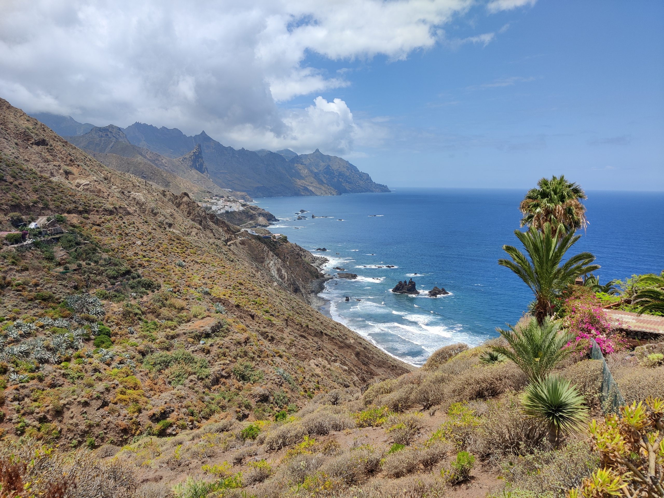
Afur – Tamadite Beach – Taganana
2h+, 5km+, 500m total elevation gain, intermediate difficulty

This may be our favorite hike in Tenerife. It starts in Afur, then follows the path down the valley (barranco) to the Tamadite Beach, and then goes along the coast towards Taganana. The views along the coast are fantastic!
Because the day was particularly hot and sunny and there is no shade at all along the way, we turned around mid-way from Tamadite Beach to Taganana and returned to Afur the way we came. If you want, you can continue all the way to Taganana and then from there back to Afur – either the same way along the coast or via the mountains in the back.
Shortly after the start in Afur, one part of the route was damaged by a landslide and a bit difficult to pass. But going carefully, this short part could still be passed safely. The rest of the route was easier and in good condition.
Make sure to check the tide timing of the Tamadite Beach before you go. When we arrived at noon, the beach was completely gone due to high tide and we could not swim.
Benijo – El Draguillo
1h 30min, 5km, 600m total elevation gain, intermediate difficulty

Benijo is known for its beautiful beach (Playa de Benijo). It also offers a great hike, again with amazing views of the surrounding mountain peaks and the coast. The hike starts at a Benijo viewpoint, where you can also park. From there, follow the road towards El Draguillo. The road is broad enough for cars but only open for people living in El Draguillo. After this easy road, walk up towards the mountains from El Draguillo and follow the path back to Benijo. At the top, you have great views onto the coast and onto Roque de Taborno.
After the hike, make sure to visit the Benijo Beach. Again, the beach is more accessible during low tide than high tide.
Punta del Hidaldo – Chinamada
3h 15min, 11km, 1200m total elevation gain, intermediate difficulty


Starting in Punta del Hidaldo, this hike starts at sea level and goes through valleys of red stones. Finally, the hike reaches the town of Chinamada. From there, only a few 100m remain to a very nice view point (Mirador Aguaide) overlooking the coast. From the viewpoint, take the same way back.
The Enchanted Forest

The enchanted forest is an old laurel forest, often covered by mist and clouds, making it look mysteriously beautiful. Some parts of the forest in Anaga are freely accessible, but for others (around El Pijaral), you need a permit. The permit is necessary to limit the amount of visitors and avoid damaging the fragile nature. You can order a permit online.
Since permits are so limited and we did not look early enough, we did not get any and could not do this hike. Still, you can drive along the road and stop at the parking places without permit and get a good impression of the forest.
Hikes in the South of Tenerife
The second part of our Tenerife hiking itinerary is set in the south of the island. The south is where most tourists stay. There are lots of huge hotels around Costa Adeje and Los Gigantes. While we try to avoid these tourist hotspots, the south also offers the Teno and Teide national parks, which are beautiful. You can find some nice hikes below. Finca Gaia La Segunda, where we stayed in the south, is far enough away from the tourists to be peacefully quite, yet close enough to quickly reach all places of interest by car.
Despite the tourists, Los Gigantes is worth a visit to see the impressive rocky coast next to the Los Gigantes beach. There is also a very nice natural pool in Los Gigantes that we enjoyed very much.
El Teide
8h, 2000m+ total elevation gain, hard difficulty
At 3718m, El Teide is the tallest mountain of Tenerife and even of Spain. There is a cable car going (almost) to the top of El Teide, but it is also possible to hike to the top. From the top, you can overlook the whole island and even see the neighboring islands if there are no clouds. If there are clouds, there is a good chance that the peak is above the clouds and you still have sunny weather at the top. The peak is even visible through the clouds from the airplane (make sure to book a window seat).

For hiking El Tide, keep a few things in mind:
- You need a permit to hike to the very peak of El Teide. Order the permit well in advance. More info here.
- You do not need a permit if you reach the peak to see the sunrise and leave it again before 9:00 AM (also see the info here).
- To see the sunrise from the top, do the entire ascent during night in darkness or hike to the Altavista Refuge the day before, sleep there, and finish the ascent in the early morning from there. Note: At the time of writing (June 2023), the refuge is closed.
- Hiking to the peak in one go during the night can be tough and should not be done without experience. Take the large and quick altitude gain into account, which can cause altitude sickness.
- You can hike up to El Teide and take the cable car back down. But keep in mind that the cable car may not go if the weather is bad. The last cable car leaves around 16:00.
Due to these complications, we did not hike up to El Teide but still have it on our bucket list for next time.
Vilaflor – Paisaje Lunar
~ 2h 30min, 9km, 800m total elevation gain, easy difficulty
The hike starts in Vilaflor, where you can find free, public parking. From Vilaflor, follow the signs out of the city and towards Paisaje Lunar. Paisaje Lunar consists of unique white stone structures looking like a lunar landscape.
You can shorten the hike (by around 5km) if you drive closer towards Paisaje Lunar, e.g., to this spot. We are not sure how easily you can park there however.
Note that the path is sometimes closed due to mouflon hunting. The hunting season is from May to November and there are signs showing the exact days during which the hunting takes place and the paths are closed. So you won’t run into danger; but, unfortunately, we did not find any website to see the closed paths up and dates front.
El Palmar – Teno Alto
2h 45min, 10km, 1000m total elevation gain, intermediate difficulty


El Palmar is a small town in the Teno national park. To reach it by car, you will have to follow the windy road partly through the famous Masca valley. The road is narrow but in very good condition and safe to drive. The drive alone is great!
From El Palmar, the hike starts hiking up the hills towards Teno Alto. While the beginning is the steepest and most exhausting part, the path is still partly covered by trees and it is often a bit cloudy such that it is not too hot. From Teno Alto, the hike goes along the ridge of the mountains with views to the valleys on both sides. Very nice!
Masca Valley

The Masca Valley is a beautiful and popular valley. Since a few years, you also need a permit to hike down into the valley. Details here. Parking is limited and the hike is quite challenging.
Even without a permit, you can drive into the Masca Valley by car all the way to Masca village. There are multiple places to stop and get out of the car to admire the beautiful nature. If you do the hike from El Palmar to Teno Alto (above), you will drive by Masca anyway and should take some time to enjoy the drive.
Tamaimo – Risco Blanco
2h 30min, 8km, 800m total elevation gain, easy/intermediate difficulty

We started this hike in Tamaimo and walked out of the town onto a simple, flat hiking path, following the signs towards El Molledo. At the crossing, follow the paths towards Risco Blanco, which is the destination of this hike. Risco Blanco is a mountain peak (the peak itself is not part of the hike) from where you have nice views onto the surrounding valleys and mountains. We also saw friendly mountain goats on the hike. From Risco Blanco, follow the path further towards El Molledo and then walk back to Tamaimo from there.
We originally had planned a different hike (towards Los Gigantes), but the valley and hiking paths in that direction were closed due to land slides and due to bird breeding. So check and follow the signs – you can often easily find other very nice hikes like this one to Risco Blanco.
We hope you found some interesting hikes and inspiration for your trip in this Tenerife hiking itinerary. Hopefully, you will enjoy the island just as much as we did.
Feel free to leave a comment if you have feedback or want to share other nice hikes.
We would be happy if you check our website for more travel inspiration and tips.
7 responses to “Tenerife Hiking Itinerary”
Great post and straight to the point. I am not sure if this is in fact the best place to ask but do you folks have any ideea where to get some professional writers?
Thank you 🙂
Have you ever thought about including a little bit more than just your articles? I mean, what you say is fundamental and all. But imagine if you added some great photos or video clips to give your posts more, “pop”! Your content is excellent but with pics and videos, this blog could undeniably be one of the greatest in its field. Good blog!
I’m glad you like the blog!
I have thought about adding videos. So far, I just haven’t gotten around to editing and creating one. But I’ll keep it in mind for future trips if you think it’d provide value.
Wow Da weiss man, wo es hingehen muss Viele Grsse Mirta
Many thanks for the information. Now I will know it.
I’m really enjoying the design and layout of your blog. It’s a very easy on the eyes which makes it much more enjoyable for me to come here and visit more often. Did you hire out a designer to create your theme? Exceptional work!
Thanks! It’s one of the standard themes with some small modifications.